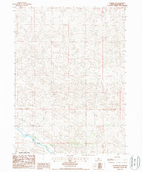
1986 Map of Dunning NW
USGS Topo · Published 1987About this map
Middle Loup River winds through the southwestern corner of this Nebraska landscape, providing a vital water source in an otherwise arid expanse of sand hills. This 1980s topographic record shows the transition from the open terrain of the central hills to the managed lands of the Nebraska National Forest. The geography is defined by a dense network of dunes and depressions, with elevations fluctuating across the sandy ridges of Blaine County. A series of unimproved roads and trails provide the only access through this section of the hills, illustrating the sparse settlement patterns and the reliance on the river corridor for connectivity. The map also delineates the precise township and range boundaries, including the intersections of t23n t22n and r25w r24w, which are essential for land tenure and genealogical research in this part of the Great Plains.
Find a feature on this map
5 named features on this map. Tap any name to fly to it.
Don’t see what you’re looking for? This feature index may not catch every label — zoom into the map to look around manually.
Map Details
Editions of this 1986 Dunning NW Map
This is the sole edition of this map. No revisions or reprints were ever made.
Other maps of this area

1948 · Halsey
USGS Topo · 1:62,500

1949 · Purdum
USGS Topo · 1:62,500

1949 · Koshopah
USGS Topo · 1:62,500

1950 · Halsey
USGS Topo · 1:62,500

1951 · Dunning
USGS Topo · 1:62,500

1951 · Purdum
USGS Topo · 1:62,500

1951 · Koshopah
USGS Topo · 1:62,500

1954 · North Platte
USGS Topo · 1:250,000

1956 · North Platte
USGS Topo · 1:250,000

1957 · North Platte
USGS Topo · 1:250,000