1932 Map of Durand
USGS Topo · Published 1932About this map
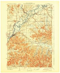
The confluence of the Chippewa River and the Red Cedar River anchors this early 1930s survey of the Wisconsin riverlands. The settlement of Durand serves as a focal point along the western bank, connected to the surrounding countryside by State Highway No 25. The landscape is defined by the heavy meanders of the rivers, creating complex formations like Ninethile Island and the Upper Bottoms, while the Chicago Milwaukee St Paul and Pacific railroad traces the corridor north toward Dunnville.
Find a feature on this map
84 named features on this map. Tap any name to fly to it.
Don’t see what you’re looking for? This feature index may not catch every label — zoom into the map to look around manually.
Map Details
Editions of this 1932 Durand Map
2 editions found
Other maps of this area

1929 · Durand
USGS Topo · 1:62,500

1932 · Gilmanton
USGS Topo · 1:62,500

1932 · Wabasha
USGS Topo · 1:62,500

1932 · Durand
USGS Topo · 1:62,500

1932 · Alma
USGS Topo · 1:62,500

1932 · Mondovi
USGS Topo · 1:62,500

1934 · Elk Mound
USGS Topo · 1:62,500

1935 · Arkansaw
USGS Topo · 1:48,000

1936 · Elk Mound
USGS Topo · 1:62,500

1940 · Menomonie
USGS Topo · 1:62,500