
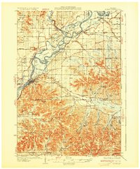
1932 Map of Durand
USGS Topo · Published 1932About this map
The Chicago Milwaukee St. Paul and Pacific railroad tracks trace the winding course of the Chippewa River through this early 1930s landscape, connecting riverbank settlements like Durand and Dunnville. The terrain is defined by the broad Wallace Dunnville Bottoms and numerous islands such as Chippewa Island, where complex slough networks like Happy Slough and Thompson Slough indicate a river system still largely dictating the local economy and movement.
Find a feature on this map
100 named features on this map. Tap any name to fly to it.
Don’t see what you’re looking for? This feature index may not catch every label — zoom into the map to look around manually.
Map Details
Editions of this 1932 Durand Map
2 editions found
Other maps of this area

1929 · Durand
USGS Topo · 1:62,500

1932 · Gilmanton
USGS Topo · 1:62,500

1932 · Wabasha
USGS Topo · 1:62,500

1932 · Alma
USGS Topo · 1:62,500

1932 · Mondovi
USGS Topo · 1:62,500

1934 · Elk Mound
USGS Topo · 1:62,500

1935 · Arkansaw
USGS Topo · 1:48,000

1936 · Elk Mound
USGS Topo · 1:62,500

1940 · Menomonie
USGS Topo · 1:62,500

1941 · Arkansaw
USGS Topo · 1:62,500