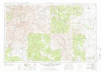
1945 Map of Durango
USGS Topo · Published 1976About this map
The San Juan Mountains and the winding Continental Divide anchor this mid-century look at Southwest Colorado, a region defined by high-altitude mining legacies and river headwaters. The industrial reach of the Denver and Rio Grande Western RR is evident as it connects isolated mountain outposts like Silverton, Eureka, and Animas Forks to the valley hub of Durango. In the north, the headwaters of the Rio Grande flow from the Rio Grande Reservoir past Creede and Wason, while to the south, the Southern Ute Indian Reservation spans the drainages of the Florida River, Animas River, and Los Pinos River. This map details the mid-century transition from a rail-dependent mining economy to one of increased water management and recreation, marked by the presence of Vallecito Reservoir and Platoro Reservoir.
Find a feature on this map
153 named features on this map. Tap any name to fly to it.
Don’t see what you’re looking for? This feature index may not catch every label — zoom into the map to look around manually.
Map Details
Editions of this 1945 Durango Map
3 editions found

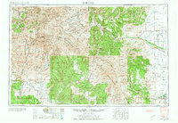
Other maps of this area

1889 · Largo
USGS Topo · 1:250,000

1889 · Chaco
USGS Topo · 1:250,000

1892 · Chaco
USGS Topo · 1:250,000

1895 · Largo
USGS Topo · 1:250,000

1895 · La Plata
USGS Topo · 1:62,500

1897 · La Plata
USGS Topo · 1:62,500

1897 · Rico
USGS Topo · 1:62,500

1897 · Telluride
USGS Topo · 1:62,500

1897 · Silverton
USGS Topo · 1:62,500

1898 · Durango
USGS Topo · 1:62,500