
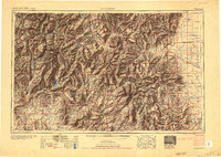
1954 Map of Durango
USGS Topo · Published 1954About this map
Durango and the high mining districts of Silverton, Ouray, and Telluride anchor the western edge of this mid-century survey, which tracks the transition from the high peaks of the San Juan Mountains to the agricultural San Luis Valley. The Denver & Rio Grande Western RR winds through the canyons, connecting the industrial centers of the San Juan basin with the farming communities of Del Norte and Monte Vista. The presence of the Southern Ute Indian Reservation and numerous rural schools like Bronson School and Blanco School highlights the diverse human geography of the Four Corners region.
Find a feature on this map
164 named features on this map. Tap any name to fly to it.
Don’t see what you’re looking for? This feature index may not catch every label — zoom into the map to look around manually.
Map Details
Editions of this 1954 Durango Map
2 editions found
Other maps of this area

1889 · Largo
USGS Topo · 1:250,000

1889 · Chaco
USGS Topo · 1:250,000

1892 · Chaco
USGS Topo · 1:250,000

1895 · Largo
USGS Topo · 1:250,000

1895 · La Plata
USGS Topo · 1:62,500

1897 · La Plata
USGS Topo · 1:62,500

1897 · Rico
USGS Topo · 1:62,500

1897 · Telluride
USGS Topo · 1:62,500

1897 · Silverton
USGS Topo · 1:62,500

1898 · Durango
USGS Topo · 1:62,500