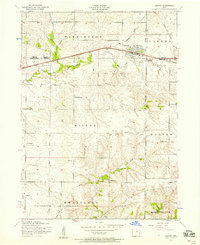
1953 Map of Durant
USGS Topo · Published 1958About this map
Durant stands as the primary hub of this agricultural landscape in the early 1950s, centered at the meeting point of Cedar, Muscatine, and Scott counties. The town is defined by its position along the Chicago Rock Island and Pacific railroad, featuring a prominent water tower, St Paul Church, and the Durant Cemetery to the east. Outside the village, the terrain is characterized by the winding paths of Little Elkhorn Creek and Mud Creek, which cut through the townships of Farmington and Wilton.
Find a feature on this map
29 named features on this map. Tap any name to fly to it.
Don’t see what you’re looking for? This feature index may not catch every label — zoom into the map to look around manually.
Map Details
Editions of this 1953 Durant Map
2 editions found
Other maps of this area

1890 · Durant
USGS Topo · 1:62,500

1891 · Wilton Junction
USGS Topo · 1:62,500

1894 · Durant
USGS Topo · 1:62,500

1901 · Rock Island
USGS Topo · 1:125,000

1901 · Stanwood
USGS Topo · 1:125,000

1910 · Rock Island
USGS Topo · 1:125,000

1916 · Edgington
USGS Topo · 1:62,500

1938 · Edgington
USGS Topo · 1:62,500

1948 · Muscatine
USGS Topo · 1:62,500

1953 · Wilton Junction
USGS Topo · 1:24,000