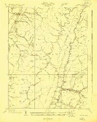
1922 Map of Durbin
USGS Topo · Published 1922About this map
Huttonsville and Durbin serve as the primary anchors of this high-altitude landscape surveyed in the early 1920s, a period when the timber and rail economy dictated the settlement patterns of the Allegheny Mountain region. The Western Maryland RR snakes through the valleys, tracing the Shavers Fork and West Fork Greenbrier River, providing vital transport for isolated communities like the Burner Settlement. The historic route of the Staunton and Parkersburg Pike cuts across the center of the sheet, crossing the mountains at Cheat Bridge.
Find a feature on this map
103 named features on this map. Tap any name to fly to it.
Don’t see what you’re looking for? This feature index may not catch every label — zoom into the map to look around manually.
Map Details
Editions of this 1922 Durbin Map
4 editions found

Other maps of this area

1889 · Beverly
USGS Topo · 1:125,000

1891 · Huntersville
USGS Topo · 1:125,000

1892 · Beverly
USGS Topo · 1:125,000

1893 · Buckhannon
USGS Topo · 1:125,000

1894 · Huntersville
USGS Topo · 1:125,000

1896 · Buckhannon
USGS Topo · 1:125,000

1897 · Buckhannon
USGS Topo · 1:125,000

1901 · Monterey
USGS Topo · 1:125,000

1909 · Elkins
USGS Topo · 1:62,500

1912 · Sago
USGS Topo · 1:48,000