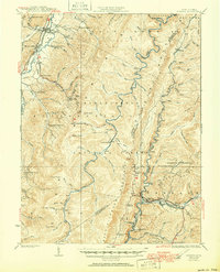
1924 Map of Durbin
USGS Topo · Published 1951About this map
Shavers Fork and the upper reaches of the West Fork Greenbrier River define this high-elevation landscape within the Monongahela National Forest. Surveyed in the early 1920s, the map documents a transition in transport and land use, where the Western Maryland RR and Chesapeake and Ohio RR connect remote timber and junction points like Durbin and Wildell. The presence of the Parkersburg and Staunton Turnpike cutting through Huttonsville highlights the region's older travel corridors alongside newer industrial rail lines.
Find a feature on this map
94 named features on this map. Tap any name to fly to it.
Don’t see what you’re looking for? This feature index may not catch every label — zoom into the map to look around manually.
Map Details
Editions of this 1924 Durbin Map
4 editions found

Other maps of this area

1889 · Beverly
USGS Topo · 1:125,000

1891 · Huntersville
USGS Topo · 1:125,000

1892 · Beverly
USGS Topo · 1:125,000

1893 · Buckhannon
USGS Topo · 1:125,000

1894 · Huntersville
USGS Topo · 1:125,000

1896 · Buckhannon
USGS Topo · 1:125,000

1897 · Buckhannon
USGS Topo · 1:125,000

1901 · Monterey
USGS Topo · 1:125,000

1909 · Elkins
USGS Topo · 1:62,500

1912 · Sago
USGS Topo · 1:48,000