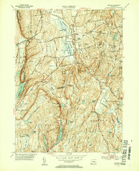
1953 Map of Durham
USGS Topo · Published 1954About this map
Durham and Durham Center serve as the primary hubs of this Connecticut landscape, situated at the head of the Durham Meadows where the Coginchaug River begins its northward flow. The village character is defined by its colonial-era layout and local industry, represented by Allyn Millpond and several brooks that once powered early mills. To the west, the steep ridges of Pistapaug Mountain and Totoket Mountain create a formidable natural boundary, punctuated by Reed Gap, which carries the New York New Haven and Hartford rail line through the highlands.
Find a feature on this map
73 named features on this map. Tap any name to fly to it.
Don’t see what you’re looking for? This feature index may not catch every label — zoom into the map to look around manually.
Map Details
Editions of this 1953 Durham Map
4 editions found

Other maps of this area

1892 · New Haven
USGS Topo · 1:62,500

1892 · Meriden
USGS Topo · 1:62,500

1893 · Guilford
USGS Topo · 1:62,500

1893 · Middletown
USGS Topo · 1:62,500

1893 · Meriden
USGS Topo · 1:62,500

1906 · Farmington
USGS Topo · 1:125,000

1921 · New Haven
USGS Topo · 1:62,500

1928 · Cromwell
USGS Topo · 1:24,000

1943 · Durham
USGS Topo · 1:25,000

1945 · Middle Haddam
USGS Topo · 1:31,680