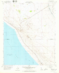
1956 Map of Durmid
USGS Topo · Published 1979About this map
The eastern shore of the Salton Sea dominates this mid-century survey, revealing a landscape defined by the arrival of infrastructure in a harsh environment. The Southern Pacific railroad runs parallel to the waterline, serving small outposts and industrial points like Ferrum, Durmid, and Bertram. These settlements, often consisting of little more than sidings or depots, supported the local extraction economy, most notably seen at the Bertram Mine situated near the Imperial County line.
Find a feature on this map
23 named features on this map. Tap any name to fly to it.
Don’t see what you’re looking for? This feature index may not catch every label — zoom into the map to look around manually.
Map Details
Editions of this 1956 Durmid Map
3 editions found
Other maps of this area

1940 · Frink
USGS Topo · 1:62,500

1940 · Cottonwood Spring
USGS Topo · 1:62,500

1940 · Canyon Spring
USGS Topo · 1:62,500

1940 · Durmid
USGS Topo · 1:62,500

1943 · Canyon Spring
USGS Topo · 1:62,500

1944 · Cottonwood Spring
USGS Topo · 1:62,500

1944 · Durmid
USGS Topo · 1:62,500

1944 · Frink
USGS Topo · 1:62,500

1954 · Salton Sea
USGS Topo · 1:250,000

1955 · Salton Sea
USGS Topo · 1:250,000