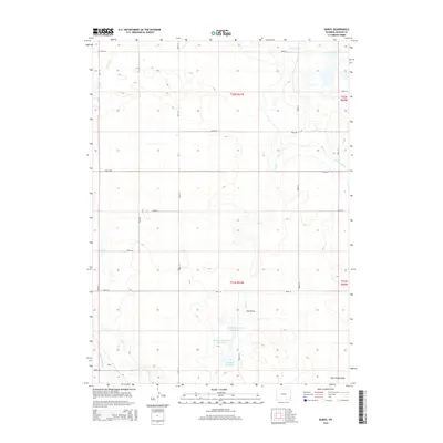
2015 Map of Duroc
USGS Topo · Published 2015About this map
The small settlement of Duroc anchors the southwest corner of this Goshen County landscape, where the High Plains are defined by an intricate network of early 21st-century irrigation and water management. Water is the primary driver of life here, evidenced by the series of catchments including McMillen Reservoir, McMillen Number 2 Reservoir, and McMillen Reservoir Number 3. These reservoirs, along with the Lewis Ditch and Hawk Springs Ditch, illustrate the engineering required to sustain agriculture in this arid region. The terrain is marked by seasonal drainage features such as Seth Smith Draw and Dry Draw, which feed into larger watercourses like Horse Cr and Dry Cr. A strictly organized grid of rural roads, including Road 44 and Road 53, provides access to the expansive range lands and scattered homesteads that characterize this part of eastern Wyoming.
Find a feature on this map
30 named features on this map. Tap any name to fly to it.
Don’t see what you’re looking for? This feature index may not catch every label — zoom into the map to look around manually.
Map Details
Editions of this 2015 Duroc Map
This is the sole edition of this map. No revisions or reprints were ever made.
Other maps of this area

1899 · Goshen Hole
USGS Topo · 1:125,000

1954 · Cheyenne
USGS Topo · 1:250,000

1958 · Cheyenne
USGS Topo · 1:250,000

1960 · Huntley
USGS Topo · 1:24,000

1960 · Mc Compsey Pass
USGS Topo · 1:24,000

1960 · Hawk Springs
USGS Topo · 1:24,000

1960 · Lyman
USGS Topo · 1:24,000

1960 · Kessler Gap
USGS Topo · 1:24,000

1960 · La Grange
USGS Topo · 1:24,000
1960 · Duroc
USGS Topo · 1:24,000