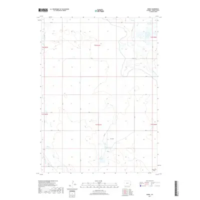
2017 Map of Duroc
USGS Topo · Published 2017About this map
Duroc sits at the southwestern edge of this Wyoming landscape, where the high plains are shaped by an intricate network of irrigation and water management systems. The reliance on water engineering is evident in the presence of the Hawk Springs Ditch and Lewis Ditch, which traverse the terrain alongside natural drainages like Horse Cr and Dry Cr. The central portion of the map is defined by several significant catchments, including McMillen Reservoir Number 3 and the McMillan Reservoir, highlighting the area's agricultural focus in Goshen County. A series of numbered county roads, such as Co RD 44 and Co RD 49, grid the landscape, providing access between the sparse settlements and the topographic features like Seth Smith Draw and Dry Draw.
Find a feature on this map
32 named features on this map. Tap any name to fly to it.
Don’t see what you’re looking for? This feature index may not catch every label — zoom into the map to look around manually.
Map Details
Editions of this 2017 Duroc Map
This is the sole edition of this map. No revisions or reprints were ever made.
Other maps of this area

1899 · Goshen Hole
USGS Topo · 1:125,000

1954 · Cheyenne
USGS Topo · 1:250,000

1958 · Cheyenne
USGS Topo · 1:250,000

1960 · Huntley
USGS Topo · 1:24,000

1960 · Mc Compsey Pass
USGS Topo · 1:24,000

1960 · Hawk Springs
USGS Topo · 1:24,000

1960 · Lyman
USGS Topo · 1:24,000

1960 · Kessler Gap
USGS Topo · 1:24,000

1960 · La Grange
USGS Topo · 1:24,000
1960 · Duroc
USGS Topo · 1:24,000