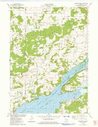
1975 Map of Durwards Glen
USGS Topo · Published 1978About this map
The North Range and South Range dominate this 1970s landscape, creating a dramatic corridor for Rowley Creek and Dog Hollow. Between these ridges, the community of Caledonia is well-defined by its social institutions, including the Caledonia Sch and several country houses of worship like St Pauls Ch. The map captures a transition from the upland agricultural tracts and numerous family cemeteries, such as the McDonald Cem and Shanks Cem, toward the recreation-heavy shoreline of Lake Wisconsin.
Find a feature on this map
73 named features on this map. Tap any name to fly to it.
Don’t see what you’re looking for? This feature index may not catch every label — zoom into the map to look around manually.
Map Details
Editions of this 1975 Durwards Glen Map
This is the sole edition of this map. No revisions or reprints were ever made.
Other maps of this area

1895 · Baraboo
USGS Topo · 1:62,500

1901 · Poynette
USGS Topo · 1:62,500

1902 · Portage
USGS Topo · 1:62,500

1902 · Briggsville
USGS Topo · 1:62,500

1908 · Baraboo
USGS Topo · 1:62,500

1957 · Madison
USGS Topo · 1:250,000

1958 · Briggsville
USGS Topo · 1:62,500

1959 · Baraboo
USGS Topo · 1:62,500

1960 · Madison
USGS Topo · 1:250,000

1962 · Poynette
USGS Topo · 1:62,500