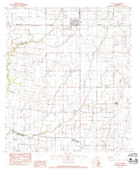
1983 Map of Duson
USGS Topo · Published 1983About this map
The low-lying prairie of south-central Louisiana is defined by the winding course of Bayou Queue de Tortue and its tributaries, including Indian Bayou and Bayou Grand Marais. This early 1980s survey captures the region as it transitions from Acadia Parish into Lafayette Parish and down toward Vermilion Parish. The settlement of Duson sits prominently along the Southern Pacific railroad line, while smaller communities like Ridge and Sadou anchor the rural landscape. Local history is preserved in several family and community landmarks, such as Bethel Cem, Anderson Cem, and the Morning Star Ch Cem. The presence of the Judice High Sch and Judice Park indicates a growing community hub near the parish line. The landscape is a network of drainage canals and agricultural plots, punctuated by the Gladney Landing Strip and small rural chapels like Kimble Chapel.
Find a feature on this map
20 named features on this map. Tap any name to fly to it.
Don’t see what you’re looking for? This feature index may not catch every label — zoom into the map to look around manually.
Map Details
Editions of this 1983 Duson Map
This is the sole edition of this map. No revisions or reprints were ever made.
Other maps of this area

1934 · Duson
USGS Topo · 1:31,680

1935 · Branch
USGS Topo · 1:31,680

1946 · Milton
USGS Topo · 1:31,680

1946 · Leroy
USGS Topo · 1:31,680

1946 · Lafayette
USGS Topo · 1:31,680

1946 · Kaplan
USGS Topo · 1:31,680

1946 · Rayne
USGS Topo · 1:31,680

1947 · Branch
USGS Topo · 1:31,680

1952 · Lake Charles
USGS Topo · 1:250,000

1954 · Lafayette
USGS Topo · 1:31,680