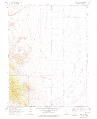
1969 Map of Dutch Flat
USGS Topo · Published 1978About this map
Dutch Flat dominates this arid Lander County landscape, a broad expanse of high-desert terrain where water is the primary driver of human presence. In the late 1960s, the ephemeral Reese River traced its path through the eastern portion of the quadrangle, supporting isolated outposts like the Visbeek Ranch. The western edge of the map rises sharply into the protected slopes of the Toiyabe National Forest, providing a stark contrast to the level valley floor.
Find a feature on this map
9 named features on this map. Tap any name to fly to it.
Don’t see what you’re looking for? This feature index may not catch every label — zoom into the map to look around manually.
Map Details
Editions of this 1969 Dutch Flat Map
2 editions found
Other maps of this area

1955 · Millett
USGS Topo · 1:250,000

1956 · North Shoshone Peak
USGS Topo · 1:62,500

1956 · Millett Ranch
USGS Topo · 1:62,500

1956 · Austin
USGS Topo · 1:62,500

1959 · Millett
USGS Topo · 1:250,000

1969 · Gandolfo Canyon
USGS Topo · 1:24,000

1969 · Emigrant Peak
USGS Topo · 1:24,000

1969 · Dutch Flat
USGS Topo · 1:24,000

1969 · Iron Mountain
USGS Topo · 1:24,000

1985 · Smith Creek Valley
USGS Topo · 1:100,000