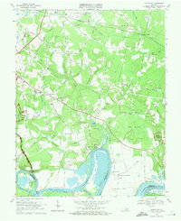
1969 Map of Dutch Gap
USGS Topo · Published 1971About this map
Jones Neck and the serpentine bends of the James River dominate this landscape southeast of Richmond, where Civil War history and 20th-century aviation converge. The map documents the extensive riverfront acreage of Curles Neck Plantation and Curles Neck Mansion, alongside numerous tactical fortifications such as Fort Harrison, Fort Brady, and various lines of Breastworks preserved within the Richmond National Battlefield Park.
Find a feature on this map
72 named features on this map. Tap any name to fly to it.
Don’t see what you’re looking for? This feature index may not catch every label — zoom into the map to look around manually.
Map Details
Editions of this 1969 Dutch Gap Map
4 editions found
Other maps of this area

1894 · Bermuda Hundred
USGS Topo · 1:62,500

1894 · Richmond
USGS Topo · 1:62,500

1895 · Richmond
USGS Topo · 1:62,500

1918 · Charles City
USGS Topo · 1:62,500

1920 · King William
USGS Topo · 1:62,500

1934 · Seven Pines
USGS Topo · 1:24,000

1934 · Richmond
USGS Topo · 1:24,000

1938 · Dutch Gap
USGS Topo · 1:24,000

1938 · Seven Pines
USGS Topo · 1:31,680

1938 · Drewrys Bluff
USGS Topo · 1:24,000