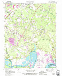
1969 Map of Dutch Gap
USGS Topo · Published 1994About this map
The James River meanders through this portion of Henrico County, shaping the distinctive peninsulas of Jones Neck and Curles Neck. This landscape is defined by its deep colonial and military roots, featuring the expansive Curles Neck Plantation and several river landings such as Picketts Wharf and Tilmans Wharf. The area’s Civil War significance is marked by Fort Harrison and Fort Brady, part of the larger Richmond National Battlefield Park system.
Find a feature on this map
76 named features on this map. Tap any name to fly to it.
Don’t see what you’re looking for? This feature index may not catch every label — zoom into the map to look around manually.
Map Details
Editions of this 1969 Dutch Gap Map
4 editions found
Other maps of this area

1894 · Bermuda Hundred
USGS Topo · 1:62,500

1894 · Richmond
USGS Topo · 1:62,500

1895 · Richmond
USGS Topo · 1:62,500

1918 · Charles City
USGS Topo · 1:62,500

1920 · King William
USGS Topo · 1:62,500

1934 · Seven Pines
USGS Topo · 1:24,000

1934 · Richmond
USGS Topo · 1:24,000

1938 · Dutch Gap
USGS Topo · 1:24,000

1938 · Seven Pines
USGS Topo · 1:31,680

1938 · Drewrys Bluff
USGS Topo · 1:24,000