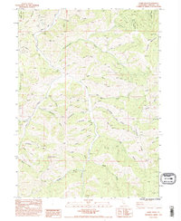
1984 Map of Duzel Rock
USGS Topo · Published 1995About this map
Klamath National Forest lands dominate the northern and eastern reaches of this Siskiyou County landscape, where the terrain is carved by an intricate network of drainages feeding into Moffett Creek. The high peaks of Antelope Mountain and Bald Hill rise above a landscape defined by ranching and resource extraction, evidenced by various Prospects and a Borrow Pit near the center of the sheet. Notable local toponyms reflect the character of the back-country, including Moonshine Gulch, Whiskey Gulch, and Clapboard Gulch. Transportation is limited to rugged routes such as Telephone Road and Scarface Road, which wind through the drainage basins of Cottonwood Creek and Duzer Creek. The prominence of Duzel Rock serves as a landmark for the western portion of the quadrangle, illustrating the transition between the forested mountain slopes and the gulch-riddled valleys.
Find a feature on this map
36 named features on this map. Tap any name to fly to it.
Don’t see what you’re looking for? This feature index may not catch every label — zoom into the map to look around manually.
Map Details
Editions of this 1984 Duzel Rock Map
2 editions found
Other maps of this area

1886 · Shasta
USGS Topo · 1:250,000

1894 · Shasta
USGS Topo · 1:250,000

1922 · Shasta Valley Sheet No 3 S
USGS Topo · 1:24,000

1923 · Sawyers Bar
USGS Topo · 1:125,000

1931 · Etna
USGS Topo · 1:96,000

1932 · Yreka
USGS Topo · 1:96,000

1934 · Etna
USGS Topo · 1:125,000

1939 · Yreka
USGS Topo · 1:125,000

1948 · Weed
USGS Topo · 1:250,000

1950 · Weed
USGS Topo · 1:250,000