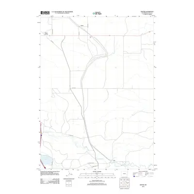
2012 Map of Dwyer
USGS Topo · Published 2012About this map
The Laramie River and its tributary, the N Laramie River, dominate the southern landscape of this Platte County region. Small agricultural settlements and transport nodes like Dwyer and Dwyer Junction are connected by a network of rural routes including Pepper Rd and Laffitte Rd. The map documents essential water management infrastructure for this arid terrain, notably the Uva Ditch and Reservoir Number 3. Cultural landmarks such as the Dwyer Cem and the settlement of Uva reflect the persistent human presence along the river valleys. The road network, featuring N Dwyer Rd and E Johnson Rd, illustrates how modern ranching and transit corridors have overlayed the historical paths through these Wyoming plains.
Find a feature on this map
18 named features on this map. Tap any name to fly to it.
Don’t see what you’re looking for? This feature index may not catch every label — zoom into the map to look around manually.
Map Details
Editions of this 2012 Dwyer Map
This is the sole edition of this map. No revisions or reprints were ever made.
Other maps of this area

1896 · Hartville
USGS Topo · 1:125,000

1901 · Hartville
USGS Topo · 1:125,000

1950 · Coleman Butte
USGS Topo · 1:24,000

1950 · Herman Ranch
USGS Topo · 1:24,000

1950 · Guernsey Reservoir
USGS Topo · 1:24,000

1951 · Coleman Butte
USGS Topo · 1:24,000

1951 · Guernsey Reservoir
USGS Topo · 1:24,000
1951 · Herman Ranch
USGS Topo · 1:24,000

1951 · Dwyer
USGS Topo · 1:24,000

1951 · Antelope Gap
USGS Topo · 1:24,000