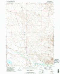
1990 Map of Dwyer
USGS Topo · Published 1995About this map
Dwyer and the neighboring Dwyer Junction anchor the northern landscape of this Platte County region, characterized by a complex network of water management and river systems. The southern portion of the quadrangle is defined by the confluence of major waterways, where the North Laramie River meets the Laramie River near the small settlement of Uva. This confluence and the presence of the Wheatland Ditch highlight the critical role of irrigation and river travel in this part of Wyoming. Local history is preserved at the Dwyer Cemetery and a designated Historical Marker located near the riverbank. The terrain is marked by numerous pipelines and water features such as Fish Creek and Reservoir No 3, illustrating the area's infrastructure for both resource transport and agricultural water rights during the late 20th century.
Find a feature on this map
15 named features on this map. Tap any name to fly to it.
Don’t see what you’re looking for? This feature index may not catch every label — zoom into the map to look around manually.
Map Details
Editions of this 1990 Dwyer Map
This is the sole edition of this map. No revisions or reprints were ever made.
Other maps of this area

1896 · Hartville
USGS Topo · 1:125,000

1901 · Hartville
USGS Topo · 1:125,000

1950 · Coleman Butte
USGS Topo · 1:24,000

1950 · Herman Ranch
USGS Topo · 1:24,000

1950 · Guernsey Reservoir
USGS Topo · 1:24,000

1951 · Coleman Butte
USGS Topo · 1:24,000

1951 · Guernsey Reservoir
USGS Topo · 1:24,000
1951 · Herman Ranch
USGS Topo · 1:24,000

1951 · Dwyer
USGS Topo · 1:24,000

1951 · Antelope Gap
USGS Topo · 1:24,000