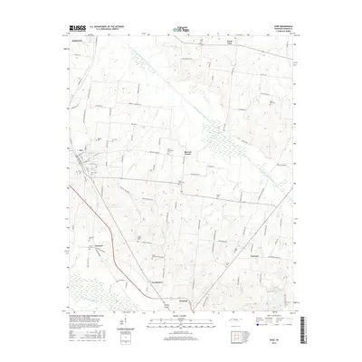
2016 Map of Dyer
USGS Topo · Published 2016About this map
Dyer and the surrounding Gibson County landscape are defined by the winding course of the Rutherford Fork Obion River and a dense network of country roads. This 2016 survey shows a region rich in family and community history, evidenced by the numerous small burial grounds and rural settlements scattered across the agricultural terrain. Places like Grizzard, Barrons Corner, and Laneview serve as local landmarks alongside more prominent towns. Genealogists will find the map particularly useful for locating smaller sites such as Bucksnort Cem, Bobbitt Cem, and Mount Sinai Cem Cotham Rd. The southern portion of the map transitions toward the N Fork Forked Deer River, illustrating the complex drainage patterns of West Tennessee. The persistence of names like Good Luck and Griers Chapel Cem reflects the long-standing community identity of this rural corridor.
Find a feature on this map
102 named features on this map. Tap any name to fly to it.
Don’t see what you’re looking for? This feature index may not catch every label — zoom into the map to look around manually.
Map Details
Editions of this 2016 Dyer Map
This is the sole edition of this map. No revisions or reprints were ever made.
Other maps of this area

1951 · Trenton
USGS Topo · 1:24,000

1952 · Milan
USGS Topo · 1:24,000

1953 · Dyer
USGS Topo · 1:24,000

1954 · Rutherford
USGS Topo · 1:24,000

1954 · Greenfield
USGS Topo · 1:24,000

1954 · Bradford
USGS Topo · 1:24,000

1956 · Dyersburg
USGS Topo · 1:250,000

1956 · Blytheville
USGS Topo · 1:250,000

1959 · Blytheville
USGS Topo · 1:250,000
1964 · Brazil
USGS Topo · 1:24,000