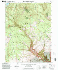
1996 Map of Dyer Mountain
USGS Topo · Published 2000About this map
Dyer Mountain dominates this portion of the Ashley National Forest, where the high-elevation landscape is defined by deep drainages and legacy mining activity. Extensive extractive operations are evident at the Dyer Mines and several nearby open pits, while the Military Trail traces a historical path through the western ridges. To the south, the terrain drops dramatically into Big Brush Gorge, a sharp contrast to the more accessible areas around Oaks Park and the Oaks Park Reservoir in the northwest. The map reveals a complex network of springs, including Davis Spring and Colton Spring, which feed the various hollows such as Kaler Hollow and Kabell Hollow. Survey control points like the Ashley Azimuth Station provide specific geographic anchors for researchers studying the 1990s forest infrastructure and resource management.
Find a feature on this map
46 named features on this map. Tap any name to fly to it.
Don’t see what you’re looking for? This feature index may not catch every label — zoom into the map to look around manually.
Map Details
Editions of this 1996 Dyer Mountain Map
This is the sole edition of this map. No revisions or reprints were ever made.
Other maps of this area

1885 · Ashley
USGS Topo · 1:250,000

1906 · Marsh Peak
USGS Topo · 1:125,000

1908 · Marsh Peak
USGS Topo · 1:125,000

1950 · Burnt Cabin Gorge
USGS Topo · 1:24,000

1950 · Dyer Mountain
USGS Topo · 1:24,000

1954 · Vernal
USGS Topo · 1:250,000

1958 · Vernal
USGS Topo · 1:250,000

1960 · Vernal
USGS Topo · 1:250,000
1963 · East Park Reservoir
USGS Topo · 1:24,000
1963 · Elk Park
USGS Topo · 1:24,000