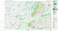
1983 Map of Dyersburg
USGS Topo · Published 1983About this map
The Mississippi River creates a dynamic border between Tennessee, Missouri, and Arkansas, defining a landscape of alluvial plains and river-bend towheads like Darnell Towhead and Stewart Towhead. East of the river, the unique hydrology of Reelfoot Lake and its surrounding wetlands, including the Reelfoot National Wildlife Refuge, stands in contrast to the rising Chickasaw Bluffs. This 1983 perspective illustrates the intersection of heavy river commerce and established rail lines such as the Illinois Central Gulf Railroad and the Burlington Northern Railroad.
Find a feature on this map
214 named features on this map. Tap any name to fly to it.
Don’t see what you’re looking for? This feature index may not catch every label — zoom into the map to look around manually.
Map Details
Editions of this 1983 Dyersburg Map
This is the sole edition of this map. No revisions or reprints were ever made.
Other maps of this area

1925 · Reelfoot Lake
USGS Topo · 1:62,500

1934 · Kennett
USGS Topo · 1:62,500

1939 · Reelfoot Lake
USGS Topo · 1:62,500

1939 · Portageville
USGS Topo · 1:62,500

1939 · Hickman
USGS Topo · 1:62,500

1939 · New Madrid
USGS Topo · 1:62,500

1939 · Bayouville
USGS Topo · 1:62,500

1939 · Dyersburg
USGS Topo · 1:62,500

1939 · Hales Point
USGS Topo · 1:62,500

1939 · Caruthersville
USGS Topo · 1:62,500