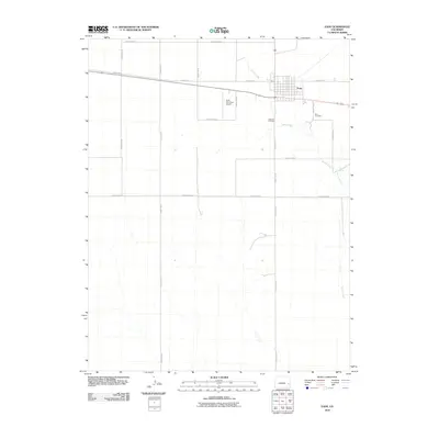
2010 Map of Eads
USGS Topo · Published 2010About this map
Eads serves as the focal point of this high-plains landscape in Kiowa County, revealing a settlement structured by a precise grid of streets and surrounded by a vast network of section roads. The town's connection to the wider region is anchored by the Eads Municipal Airport and a primary east-west highway corridor. To the south and east of the town center, the terrain is marked by the intermittent drainage of Kiowa Creek, which leads toward the Kiowa Spring. Local history and genealogy are well-represented by the inclusion of both the Eads Cemetery and the Eads Old Cemetery, offering a clear view of the community's established footprint. The map's uniform grid of county roads, such as County Road T and County Rd 36, illustrates the systematic land division characteristic of the Colorado plains in the early 21st century.
Find a feature on this map
19 named features on this map. Tap any name to fly to it.
Don’t see what you’re looking for? This feature index may not catch every label — zoom into the map to look around manually.
Map Details
Editions of this 2010 Eads Map
This is the sole edition of this map. No revisions or reprints were ever made.
Other maps of this area

1891 · Kit Carson
USGS Topo · 1:125,000

1892 · Lamar
USGS Topo · 1:125,000

1893 · Kit Carson
USGS Topo · 1:125,000

1954 · Lamar
USGS Topo · 1:250,000

1958 · Lamar
USGS Topo · 1:250,000

1967 · Neenoshe Reservoir
USGS Topo · 1:24,000

1968 · Rose Ranch
USGS Topo · 1:24,000
1968 · Alkali Lake
USGS Topo · 1:24,000
1968 · Swede Lake
USGS Topo · 1:24,000

1968 · Hawkins
USGS Topo · 1:24,000