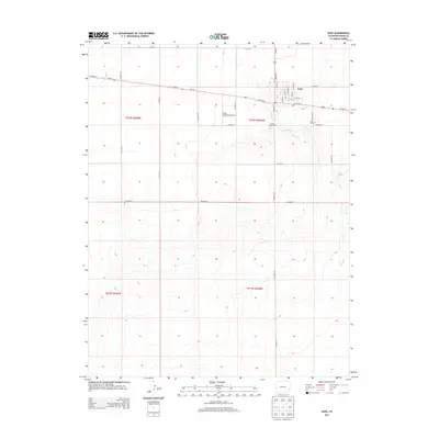
2013 Map of Eads
USGS Topo · Published 2013About this map
Eads serves as the focal point of this high plains landscape in Kiowa County, situated at the intersection of Us-287 N and Co-96. The town grid is clearly defined by local thoroughfares such as Maine St, Wansted St, and Luther St, reflecting a traditional agricultural hub layout. Genealogists and local historians can distinguish between the Eads Cem and the Eads Old Cem, located just south of the main settlement area near the Eads Municipal Airport. The surrounding terrain is characterized by the ephemeral drainage of Kiowa Cr, which winds through the eastern portion of the survey. The presence of Kiowa Spring further east suggests a vital water source in this semi-arid region, while a dense network of section-line roads, including Co Road S and Co Road N, illustrates the orderly division of the surrounding prairie for ranching and farming operations.
Find a feature on this map
36 named features on this map. Tap any name to fly to it.
Don’t see what you’re looking for? This feature index may not catch every label — zoom into the map to look around manually.
Map Details
Editions of this 2013 Eads Map
This is the sole edition of this map. No revisions or reprints were ever made.
Other maps of this area

1891 · Kit Carson
USGS Topo · 1:125,000

1892 · Lamar
USGS Topo · 1:125,000

1893 · Kit Carson
USGS Topo · 1:125,000

1954 · Lamar
USGS Topo · 1:250,000

1958 · Lamar
USGS Topo · 1:250,000

1967 · Neenoshe Reservoir
USGS Topo · 1:24,000

1968 · Rose Ranch
USGS Topo · 1:24,000
1968 · Alkali Lake
USGS Topo · 1:24,000
1968 · Swede Lake
USGS Topo · 1:24,000

1968 · Hawkins
USGS Topo · 1:24,000