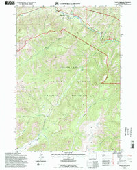
1991 Map of Eagle Creek
USGS Topo · Published 1997About this map
Middle Fork Shoshone River carves a deep path through this section of the Shoshone National Forest, serving as a primary corridor for travel and recreation in the early 1990s. The settlement of Pahaska and the Sleeping Giant Winter Sports Area mark the northwestern corner, where the topography transitions into the designated Absaroka Wilderness. A distinct mining history is evident further south near Crouch Creek at the Crouch Mine, situated among the steep drainages that feed into Eagle Creek. Most of the landscape is dominated by the Washakie Wilderness, a primitive expanse where drainage networks like Kitty Creek and Cloudburst Creek converge toward the Eagle Creek Meadows. The map reveals a land defined by high-elevation watersheds and the limited footprint of human industry, primarily confined to the river valley and scattered historical mining claims.
Find a feature on this map
25 named features on this map. Tap any name to fly to it.
Don’t see what you’re looking for? This feature index may not catch every label — zoom into the map to look around manually.
Map Details
Editions of this 1991 Eagle Creek Map
2 editions found
Other maps of this area

1885 · Lake
USGS Topo · 1:125,000

1886 · Canyon
USGS Topo · 1:125,000

1893 · Ishawooa
USGS Topo · 1:125,000

1895 · Ishawooa
USGS Topo · 1:125,000

1895 · Canyon
USGS Topo · 1:125,000

1895 · Lake
USGS Topo · 1:125,000

1896 · Lake
USGS Topo · 1:125,000

1896 · Canyon
USGS Topo · 1:125,000

1896 · Crandall Creek
USGS Topo · 1:125,000

1899 · Crandall
USGS Topo · 1:125,000