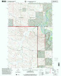
1997 Map of Eagle Draw
USGS Topo · Published 2001About this map
The Little Missouri National Grassland dominates this landscape in the late 1990s, where the winding Little Missouri River carves through the badlands of the Medora Ranger District. The map documents a rugged drainage network including Eagle Draw, Six Creek, and Porcupine Creek, which feed into the river valley. Human presence is sparse, defined by the Goldsberry Ranch and a series of deep extraction sites labeled as wells scattered across the drainages.
Find a feature on this map
17 named features on this map. Tap any name to fly to it.
Don’t see what you’re looking for? This feature index may not catch every label — zoom into the map to look around manually.
Map Details
Editions of this 1997 Eagle Draw Map
This is the sole edition of this map. No revisions or reprints were ever made.
Other maps of this area

1953 · Watford City
USGS Topo · 1:250,000

1957 · Watford City
USGS Topo · 1:250,000

1967 · Watford City
USGS Topo · 1:250,000

1970 · Eagle Draw
USGS Topo · 1:24,000

1970 · Hanks Gully
USGS Topo · 1:24,000

1970 · Roosevelt Creek East
USGS Topo · 1:24,000

1974 · Trotters SE
USGS Topo · 1:24,000

1974 · Roosevelt Creek West
USGS Topo · 1:24,000
1974 · Ice Box Canyon
USGS Topo · 1:24,000
1974 · Cinnamon Creek
USGS Topo · 1:24,000