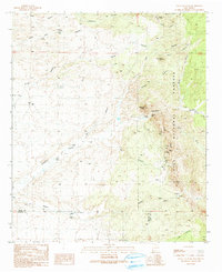
1990 Map of Eagle Eye Peak
USGS Topo · Published 1991About this map
Eagle Eye Peak and the high desert ridges of the Gila National Forest dominate this southwestern New Mexico landscape on the border of Grant and Hidalgo counties. Mapping in 1990 reveals an area defined by mineral exploration and livestock management, with numerous prospects, mine shafts, and the Malone Mines clustered along Brock Ridge. The terrain is deeply incised by a network of drainage systems including Thompson Canyon, Ray Canyon, and Knight Canyon, where man-made infrastructure like check dams, levees, and corrals indicate active land use for cattle ranching.
Find a feature on this map
41 named features on this map. Tap any name to fly to it.
Don’t see what you’re looking for? This feature index may not catch every label — zoom into the map to look around manually.
Map Details
Editions of this 1990 Eagle Eye Peak Map
This is the sole edition of this map. No revisions or reprints were ever made.
Other maps of this area

1909 · Silver City
USGS Topo · 1:125,000

1950 · Wind Mountain
USGS Topo · 1:24,000

1950 · Burro Peak
USGS Topo · 1:24,000

1951 · Big Burro Mountains
USGS Topo · 1:24,000

1951 · Wind Mountain
USGS Topo · 1:24,000

1954 · Silver City
USGS Topo · 1:250,000

1958 · Silver City
USGS Topo · 1:250,000

1959 · Redrock
USGS Topo · 1:62,500

1962 · Silver City
USGS Topo · 1:250,000

1963 · Gold Hill
USGS Topo · 1:24,000