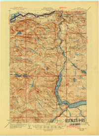
1931 Map of Eagle Lake
USGS Topo · Published 1944About this map
Fort Kent and the winding St John River anchor this northern Maine landscape, illustrating a borderland economy built on timber and agriculture during the early twentieth century. The Bangor and Aroostook Railroad parallels the river and the northern reaches of Eagle Lake, connecting logging outposts like Michaud Siding and Wheelock Siding to larger markets. The map reveals a dense network of localized educational and religious life, featuring numerous namesake schools such as Shakespeare Sch and St Elizabeth Sch, alongside the St Marys Ch.
Find a feature on this map
122 named features on this map. Tap any name to fly to it.
Don’t see what you’re looking for? This feature index may not catch every label — zoom into the map to look around manually.
Map Details
Editions of this 1931 Eagle Lake Map
4 editions found
Other maps of this area

1927 · Square Lake
USGS Topo · 1:48,000

1928 · Eagle Lake
USGS Topo · 1:48,000

1928 · Winterville
USGS Topo · 1:48,000

1929 · Portage
USGS Topo · 1:62,500

1930 · St Francis
USGS Topo · 1:48,000

1931 · Square Lake
USGS Topo · 1:62,500

1931 · Fish River Lake
USGS Topo · 1:48,000

1931 · Eagle Lake
USGS Topo · 1:62,500

1931 · Portage
USGS Topo · 1:62,500

1931 · Winterville
USGS Topo · 1:62,500