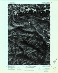
1975 Map of Eagle Lake NW
USGS Topo · Published 1981About this map
The St John River forms the defining international border on this orthophotoquad, separating Northern Maine from New Brunswick, Canada. This aerial perspective shows the concentrated agricultural activity along the river valley, where cleared fields and farmstead structures contrast sharply with the dense timberlands to the south. The small settlement of Wheelock is situated on the southern bank, nestled near the wooded elevations that rise toward Wheelock Lake. The imagery reveals a complex network of logging roads and forest management patterns across the township of Wallagrass, providing a clear view of the mid-1970s timber economy. Along the river's path, the Ledges create a distinctive geological break in the shoreline, marking a point of interest for local navigation and history.
Find a feature on this map
7 named features on this map. Tap any name to fly to it.
Don’t see what you’re looking for? This feature index may not catch every label — zoom into the map to look around manually.
Map Details
Editions of this 1975 Eagle Lake NW Map
This is the sole edition of this map. No revisions or reprints were ever made.
Other maps of this area

1928 · Eagle Lake
USGS Topo · 1:48,000

1930 · St Francis
USGS Topo · 1:48,000

1931 · Eagle Lake
USGS Topo · 1:62,500

1932 · Fort Kent
USGS Topo · 1:48,000

1933 · St Francis
USGS Topo · 1:62,500

1935 · Fort Kent
USGS Topo · 1:62,500

1962 · Edmundston
USGS Topo · 1:250,000
1975 · St Francis SE
USGS Topo · 1:24,000
1975 · St Francis NE
USGS Topo · 1:24,000
1975 · Fort Kent SE
USGS Topo · 1:24,000