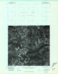
1975 Map of Fort Kent SE
USGS Topo · Published 1981About this map
The St John River carves a deep valley through this borderland, serving as the international boundary between Maine and New Brunswick in the mid-1970s. This orthophotoquad captures the agrarian landscape of the St. John Valley, where long, narrow farm strips extend away from the riverbanks, a pattern characteristic of the region's Acadian heritage. The town of Fort Kent sits at the confluence with the Fish River, serving as a primary hub for commerce and transport on the American side. Across the water, the Canadian settlements of Baker Brook and Clair line the northern shore. Unlike traditional topographic maps, this aerial imagery reveals the exact footprint of woodlots and cleared fields, providing a literal view of land use during a period when the local economy was deeply tied to both timber and agriculture.
Find a feature on this map
11 named features on this map. Tap any name to fly to it.
Don’t see what you’re looking for? This feature index may not catch every label — zoom into the map to look around manually.
Map Details
Editions of this 1975 Fort Kent SE Map
This is the sole edition of this map. No revisions or reprints were ever made.
Other maps of this area

1927 · Square Lake
USGS Topo · 1:48,000

1928 · Eagle Lake
USGS Topo · 1:48,000

1931 · Square Lake
USGS Topo · 1:62,500

1931 · Eagle Lake
USGS Topo · 1:62,500

1932 · Frenchville
USGS Topo · 1:48,000

1932 · Fort Kent
USGS Topo · 1:48,000

1935 · Fort Kent
USGS Topo · 1:62,500

1935 · Frenchville
USGS Topo · 1:62,500

1953 · Square Lake
USGS Topo · 1:62,500

1962 · Edmundston
USGS Topo · 1:250,000