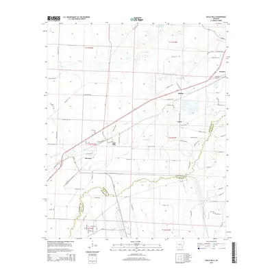
2014 Map of Eagle Mills
USGS Topo · Published 2014About this map
Bearden and Millville serve as central hubs in this corner of southern Arkansas, where the landscape is defined by the winding course of Two Bayou and its many tributaries. The area's development is closely tied to the railroad corridor that connects Eagle Mills to the larger town of Bearden, reflecting the regional importance of timber and transit in the early 21st century. The map reveals a dense network of county roads, such as Ouachita 232 Rd and Calhoun 298, which stitch together small settlements and rural landmarks. For those studying local heritage or genealogy, the inclusion of Evans Cem and small communities like Salem provides essential points of reference for identifying historic family homesteads and the spatial layout of Ouachita and Calhoun counties before modern expansion altered the rural character of these woodlands.
Find a feature on this map
77 named features on this map. Tap any name to fly to it.
Don’t see what you’re looking for? This feature index may not catch every label — zoom into the map to look around manually.
Map Details
Editions of this 2014 Eagle Mills Map
This is the sole edition of this map. No revisions or reprints were ever made.
Other maps of this area

1903 · Camden
USGS Topo · 1:125,000

1951 · Camden
USGS Topo · 1:24,000

1953 · El Dorado
USGS Topo · 1:250,000

1957 · El Dorado
USGS Topo · 1:250,000

1958 · El Dorado
USGS Topo · 1:250,000

1960 · El Dorado
USGS Topo · 1:250,000

1971 · Ouachita
USGS Topo · 1:24,000
1971 · Harmony Grove
USGS Topo · 1:24,000
1971 · Camden
USGS Topo · 1:24,000

1973 · Bearden
USGS Topo · 1:24,000