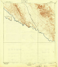
1897 Map of Eagle Mountain
USGS Topo · Published 1942About this map
The Rio Grande snakes along the international United States Mexico boundary, defining the southern edge of this West Texas survey. Conducted in the 1890s by W.J. Lloyd under the direction of Henry Gannett, the map documents a sparse and arid landscape dominated by the Quitman Mountains and the prominent heights of Eagle Mt. Settled life is limited to isolated outposts like Phinney's Ranch, reflecting the difficult terrain of El Paso County before modern development. Water sources are the primary landmarks for travel and survival, including the remote Hot Spring near the river and the essential Eagle Spring further inland. The vast Quitman Arroyo cuts through the center of the sheet, illustrating the drainage patterns that shaped regional transit routes during the late nineteenth century.
Find a feature on this map
10 named features on this map. Tap any name to fly to it.
Don’t see what you’re looking for? This feature index may not catch every label — zoom into the map to look around manually.
Map Details
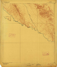
Editions of this 1897 Eagle Mountain Map
3 editions found
Other maps of this area

1892 · Chispa
USGS Topo · 1:125,000

1894 · Fort Hancock
USGS Topo · 1:125,000

1895 · Chispa
USGS Topo · 1:125,000

1895 · Sierra Blanca
USGS Topo · 1:125,000

1896 · San Carlos
USGS Topo · 1:125,000

1897 · Eagle Mountain
USGS Topo · 1:125,000

1897 · Chispa
USGS Topo · 1:125,000

1906 · Van Horn
USGS Topo · 1:125,000

1916 · Eagle Mountain
USGS Topo · 1:125,000

1943 · Fort Quitman
USGS Topo · 1:62,500