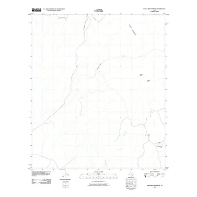
2010 Map of Eagle Mountains SE
USGS Topo · Published 2010About this map
Eagle Mountains dominate this high-desert landscape in Hudspeth County, showing a network of canyons and isolated springs typical of West Texas. The southeastern foothills are marked by the Black Diamond Mine in Echo Canyon, a site of historic mineral exploration. Transportation in this arid region is defined by unpaved routes such as Oxford Canyon Rd and Broad Canyon Rd, which navigate the steep terrain between Squaw Peak and Squaw Pass. Human presence is sparse, centered around the Indio Ranch and vital water sources like Oxford Spring and Squaw Spring. The map illustrates a reliance on these natural catchments and deep drainages like Cottonwood Canyon and Squaw Creek, which are critical for livestock and wildlife in this part of the Trans-Pecos.
Find a feature on this map
14 named features on this map. Tap any name to fly to it.
Don’t see what you’re looking for? This feature index may not catch every label — zoom into the map to look around manually.
Map Details
Editions of this 2010 Eagle Mountains SE Map
This is the sole edition of this map. No revisions or reprints were ever made.
Other maps of this area

1892 · Chispa
USGS Topo · 1:125,000

1895 · Chispa
USGS Topo · 1:125,000

1897 · Eagle Mountain
USGS Topo · 1:125,000

1897 · Chispa
USGS Topo · 1:125,000

1916 · Eagle Mountain
USGS Topo · 1:125,000

1959 · Marfa
USGS Topo · 1:250,000

1965 · Marfa
USGS Topo · 1:250,000
1972 · Lobo SW
USGS Topo · 1:24,000
1972 · Eagle Mountains NW
USGS Topo · 1:24,000
1972 · Bramlett Ranch
USGS Topo · 1:24,000