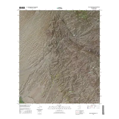
2016 Map of Eagle Mountains SE
USGS Topo · Published 2016About this map
The high peaks of the Eagle Mountains dominate this region of Hudspeth County, showing a landscape defined by deep drainages and scarce water sources. The map records several vital springs that have long served as navigation points in the arid terrain, including Oxford Spring and Squaw Spring. High points such as Squaw Peak and the nearby Squaw Pass provide structural landmarks for the surrounding network of canyons. The drainage pattern is carved through several named features like Cottonwood Canyon, Echo Canyon, and Oxford Canyon, which converge into broader washes. This survey reflects the modern road access to these remote elevations via Broad Canyon Rd, Summit Rd, and Oxford Canyon Rd, providing a detailed look at the topography as it existed in the mid-2010s.
Find a feature on this map
13 named features on this map. Tap any name to fly to it.
Don’t see what you’re looking for? This feature index may not catch every label — zoom into the map to look around manually.
Map Details
Editions of this 2016 Eagle Mountains SE Map
This is the sole edition of this map. No revisions or reprints were ever made.
Other maps of this area

1892 · Chispa
USGS Topo · 1:125,000

1895 · Chispa
USGS Topo · 1:125,000

1897 · Eagle Mountain
USGS Topo · 1:125,000

1897 · Chispa
USGS Topo · 1:125,000

1916 · Eagle Mountain
USGS Topo · 1:125,000

1959 · Marfa
USGS Topo · 1:250,000

1965 · Marfa
USGS Topo · 1:250,000
1972 · Lobo SW
USGS Topo · 1:24,000
1972 · Eagle Mountains NW
USGS Topo · 1:24,000
1972 · Bramlett Ranch
USGS Topo · 1:24,000