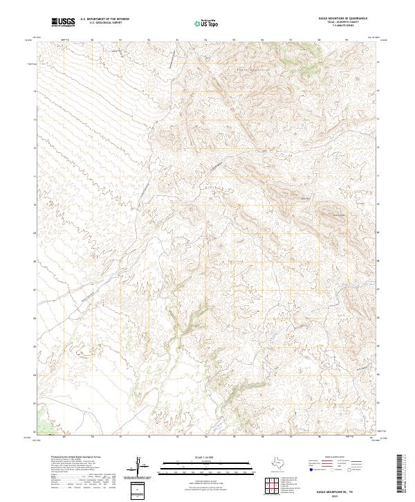
2023 Map of Eagle Mountains SE
USGS Topo · Published 2023About this map
The Eagle Mountains dominate this high-desert landscape in Hudspeth County, characterized by steep elevation changes and a complex network of dry washes and canyons. This 2023 survey illustrates the dramatic topography surrounding Echo Peak and the transit through Echo Pass, providing a clear record of the area's natural drainage patterns. Water sources, vital in this arid environment, are specifically identified at Oxford Spring and Echo Spring, which feed into seasonal drainages like Echo Creek. Human activity is primarily represented by a sparse network of unpaved access routes, including Oxford Canyon Rd and Summit Rd, which navigate the difficult terrain of Cottonwood Canyon and Oxford Canyon. The map reveals a largely uninhabited region where the physical geography dictates the placement of every trail and road.
Find a feature on this map
12 named features on this map. Tap any name to fly to it.
Don’t see what you’re looking for? This feature index may not catch every label — zoom into the map to look around manually.
Map Details
Editions of this 2023 Eagle Mountains SE Map
This is the sole edition of this map. No revisions or reprints were ever made.
Other maps of this area

1892 · Chispa
USGS Topo · 1:125,000

1895 · Chispa
USGS Topo · 1:125,000

1897 · Eagle Mountain
USGS Topo · 1:125,000

1897 · Chispa
USGS Topo · 1:125,000

1916 · Eagle Mountain
USGS Topo · 1:125,000

1959 · Marfa
USGS Topo · 1:250,000

1965 · Marfa
USGS Topo · 1:250,000
1972 · Lobo SW
USGS Topo · 1:24,000
1972 · Eagle Mountains NW
USGS Topo · 1:24,000
1972 · Bramlett Ranch
USGS Topo · 1:24,000