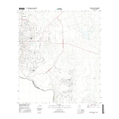
2016 Map of Eagle Pass East
USGS Topo · Published 2016About this map
The Rio Grande forms a prominent international boundary here, separating the growing neighborhoods of Eagle Pass from the neighboring Mexican state of Coahuila. This 2016 survey highlights the expanding residential and industrial footprint of the border region, featuring established areas like Seco Mines and Eidson Road. The landscape is a mix of urban street grids and desert water management, including Maverick County Lake and City Lake. To the south, smaller communities like Chula Vista and Rosita sit near the winding banks of Rosita Cr, while the northern portion of the quadrangle is defined by drainage features such as Seco Cr. The presence of Carr Lake and various numbered tanks underscore the importance of water storage in this semi-arid terrain, where infrastructure like Loop 431 and Truck Rte facilitates the heavy trade and movement characteristic of this significant Texas gateway.
Find a feature on this map
78 named features on this map. Tap any name to fly to it.
Don’t see what you’re looking for? This feature index may not catch every label — zoom into the map to look around manually.
Map Details
Editions of this 2016 Eagle Pass East Map
This is the sole edition of this map. No revisions or reprints were ever made.
Other maps of this area

1940 · Eagle Pass
USGS Topo · 1:62,500

1940 · Paloma
USGS Topo · 1:62,500

1940 · Quemado
USGS Topo · 1:62,500

1958 · Eagle Pass
USGS Topo · 1:250,000

1965 · Eagle Pass
USGS Topo · 1:250,000
1974 · Indian Tank
USGS Topo · 1:24,000
1974 · Deadmans Hill
USGS Topo · 1:24,000
1974 · Quemado SE
USGS Topo · 1:24,000
1982 · Eagle Pass NE
USGS Topo · 1:24,000
1983 · Eagle Pass East
USGS Topo · 1:24,000
Featured Places
- Eagle Pass, TX
- Chula Vista, TX
- Las Quintas Fronterizas, TX
- Los Guajillos Colonia, TX
- Morales Number 2 East Colonia, TX