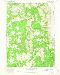
1963 Map of Eagle Peak
USGS Topo · Published 1965About this map
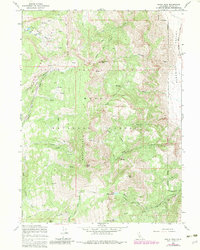
Eagle Peak stands as the centerpiece of this high-elevation landscape within the Modoc National Forest, where a complex network of headwaters feeds into the Surprise Valley to the east. The terrain is defined by prominent summits such as Dusenbery Peak and Cole Peak, with the notable Saddleback ridge separating diverse drainage basins. In the southern portion of the survey, the high-altitude North Emerson Lake and South Emerson Lake serve as the source for Emerson Creek, illustrating the typical glacial or volcanic catchment patterns of the Warner Mountains. The scarcity of established roads, marked only by occasional trails, suggests a remote timber and grazing environment. Notable family or local place names like Hornback Creek and Raider Creek indicate early ranching or pioneer activity in the canyons below the basin, while features like Poison Flat and South Pine Creek Basin reveal the localized topography used by early foresters and surveyors.
Find a feature on this map
35 named features on this map. Tap any name to fly to it.
Don’t see what you’re looking for? This feature index may not catch every label — zoom into the map to look around manually.
Map Details
Editions of this 1963 Eagle Peak Map
5 editions found
Other maps of this area

1886 · Alturas
USGS Topo · 1:250,000

1892 · Alturas
USGS Topo · 1:250,000

1954 · Alturas
USGS Topo · 1:250,000

1958 · Alturas
USGS Topo · 1:250,000

1962 · Alturas
USGS Topo · 1:250,000

1962 · Snake Lake
USGS Topo · 1:24,000

1962 · Jess Valley
USGS Topo · 1:24,000
1962 · Emerson Peak
USGS Topo · 1:24,000

1963 · Warren Peak
USGS Topo · 1:24,000
1963 · Hansen Island
USGS Topo · 1:24,000