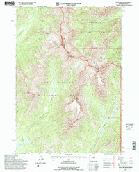
1991 Map of Eagle Peak
USGS Topo · Published 1996About this map
Yellowstone National Park and the Shoshone National Forest meet at a high continental divide defined by prominent summits like Mount Schurz, Mount Humphreys, and Eagle Peak. This 1991 revision, based on 1980s aerial photography, documents a wilderness landscape managed by the U.S. Forest Service and the Department of the Interior. The boundary between the national park and the Washakie Wilderness follows the ridgeline, where water flows into drainages like Eagle Creek and Beaverdam Creek.
Find a feature on this map
18 named features on this map. Tap any name to fly to it.
Don’t see what you’re looking for? This feature index may not catch every label — zoom into the map to look around manually.
Map Details
Editions of this 1991 Eagle Peak Map
This is the sole edition of this map. No revisions or reprints were ever made.
Other maps of this area

1885 · Lake
USGS Topo · 1:125,000

1893 · Ishawooa
USGS Topo · 1:125,000

1895 · Ishawooa
USGS Topo · 1:125,000

1895 · Lake
USGS Topo · 1:125,000

1896 · Lake
USGS Topo · 1:125,000

1899 · Ishawooa
USGS Topo · 1:125,000

1901 · Lake
USGS Topo · 1:125,000

1906 · Lake
USGS Topo · 1:125,000

1911 · Lake
USGS Topo · 1:125,000

1955 · Ashton
USGS Topo · 1:250,000