1911 Map of Lake
USGS Topo · Published 1911About this map
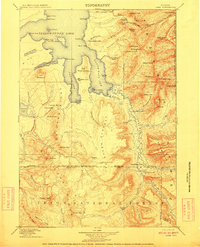
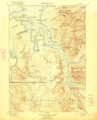
Yellowstone Lake dominates the northern half of this 1911 survey, showing its intricate shoreline from Breeze Point down to the fingers of South Arm and South East Arm. The terrain is defined by the Continental Divide winding through the high country of Two Ocean Plateau. A notable hydrologic curiosity is captured at Two Ocean Pass, where the waters of Atlantic Creek and Pacific Creek part ways toward different oceans. Remote outposts like the Snowshoe Cabin near Mariposa Lake and Hawks Rest along the Snake River indicate the sparse human presence in this protected wilderness. The map details a landscape of high peaks such as Avalanche Peak and Eagle Peak, connected by early routes like the Cody Road entering from the east. This edition reflects the early administrative boundaries between Yellowstone National Park and Teton National Forest during a period of foundational wilderness management.
Find a feature on this map
100 named features on this map. Tap any name to fly to it.
Don’t see what you’re looking for? This feature index may not catch every label — zoom into the map to look around manually.
Map Details
Editions of this 1911 Lake Map
2 editions found
Other maps of this area

1885 · Lake
USGS Topo · 1:125,000

1885 · Gallatin
USGS Topo · 1:125,000

1885 · Gallatin
USGS Topo · 1:125,000

1886 · Shoshone
USGS Topo · 1:125,000

1886 · Canyon
USGS Topo · 1:125,000

1888 · Shoshone
USGS Topo · 1:125,000
1893 · Ishawooa
USGS Topo · 1:125,000

1895 · Shoshone
USGS Topo · 1:125,000
1895 · Ishawooa
USGS Topo · 1:125,000

1895 · Canyon
USGS Topo · 1:125,000