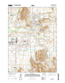
2014 Map of Eagle Point
USGS Topo · Published 2014About this map
Eagle Point and White City anchor this 2014 study of the Rogue Valley landscape, where suburban expansion meets an intricate system of water management. The Medford Irrigation District Canal and Medford Aqueduct wind through the terrain, feeding numerous local impoundments such as Agate Reservoir, Mayes Reservoir, and the Hoover Pond Number One complex. These features illustrate the region's historical reliance on engineering to support its development and agriculture north of Medford.
Find a feature on this map
156 named features on this map. Tap any name to fly to it.
Don’t see what you’re looking for? This feature index may not catch every label — zoom into the map to look around manually.
Map Details
Editions of this 2014 Eagle Point Map
This is the sole edition of this map. No revisions or reprints were ever made.
Other maps of this area

1891 · Ashland
USGS Topo · 1:250,000

1893 · Ashland
USGS Topo · 1:250,000

1897 · Ashland
USGS Topo · 1:250,000

1938 · Medford
USGS Topo · 1:125,000

1943 · Trail
USGS Topo · 1:62,500

1954 · Medford
USGS Topo · 1:62,500

1954 · Butte Falls
USGS Topo · 1:62,500

1954 · Lakecreek
USGS Topo · 1:62,500

1955 · Medford
USGS Topo · 1:250,000

1957 · Medford
USGS Topo · 1:250,000