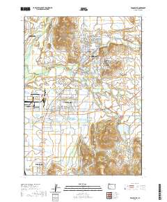
2020 Map of Eagle Point
USGS Topo · Published 2020About this map
Rogue River flows through the northwest corner of this Jackson County survey, anchoring a landscape where agricultural heritage meets modern infrastructure. The community of Eagle Point serves as a focal point, surrounded by significant water management features including the Crater Canal and Barton Reservoir. Further south, the industrial and residential grid of White City dominates the terrain, illustrating the intensive development of the Rogue Valley floor. This area is characterized by a sophisticated network of irrigation, featuring the Medford Irrigation District Canal and numerous catchment basins like Agate Reservoir and the Hoover Reservoirs. Local family history is preserved at sites such as Antelope Cem and Nichols Cem, while prominent elevations like Coker Butte and Young Hill provide natural landmarks above the developed valley. The map also traces aviation corridors serving the region via the Rogue Valley International - Medford Airport on the northern outskirts of Medford.
Find a feature on this map
155 named features on this map. Tap any name to fly to it.
Don’t see what you’re looking for? This feature index may not catch every label — zoom into the map to look around manually.
Map Details
Editions of this 2020 Eagle Point Map
This is the sole edition of this map. No revisions or reprints were ever made.
Other maps of this area

1891 · Ashland
USGS Topo · 1:250,000

1893 · Ashland
USGS Topo · 1:250,000

1897 · Ashland
USGS Topo · 1:250,000

1938 · Medford
USGS Topo · 1:125,000

1943 · Trail
USGS Topo · 1:62,500

1954 · Medford
USGS Topo · 1:62,500

1954 · Butte Falls
USGS Topo · 1:62,500

1954 · Lakecreek
USGS Topo · 1:62,500

1955 · Medford
USGS Topo · 1:250,000

1957 · Medford
USGS Topo · 1:250,000