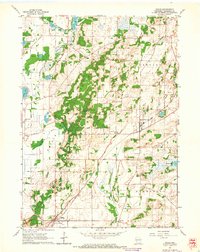
1960 Map of Eagle
USGS Topo · Published 1964About this map
Kettle Moraine State Forest dominates the central landscape of this 1960s survey, illustrating the glacial topography of Waukesha County. The corridor of the Chicago Milwaukee St Paul and Pacific railroad acts as a primary artery for the region, connecting the larger settlements of Eagle and North Prairie with the outlying Genesee Depot. The map records a rural network of social and civic anchors, including the Scuppernong Ranger Station, North Prairie Cem, and the Salem Ch.
Find a feature on this map
44 named features on this map. Tap any name to fly to it.
Don’t see what you’re looking for? This feature index may not catch every label — zoom into the map to look around manually.
Map Details
Editions of this 1960 Eagle Map
3 editions found
Other maps of this area

1892 · Watertown
USGS Topo · 1:62,500

1892 · Oconomowoc
USGS Topo · 1:62,500

1892 · Whitewater
USGS Topo · 1:62,500

1892 · Eagle
USGS Topo · 1:62,500

1893 · Whitewater
USGS Topo · 1:62,500

1894 · Watertown
USGS Topo · 1:62,500

1894 · Eagle
USGS Topo · 1:62,500

1897 · Eagle
USGS Topo · 1:62,500

1903 · Whitewater
USGS Topo · 1:62,500

1906 · Eagle
USGS Topo · 1:62,500