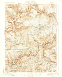
1932 Map of Eagles Mere
USGS Topo · Published 1932About this map
Eagles Mere and its eponymous Eagles Mere Lake serve as a focal point for this early 1930s survey of the Sullivan and Lycoming county borderlands. The landscape is defined by the steep relief of North Mountain, High Knob, and Chestnut Ridge, with the winding course of Loyalsock Creek and Muncy Creek carving deep valleys through the plateau. A dense network of rural infrastructure is visible, featuring numerous one-room schoolhouses like Bunker Hill Sch and Rock Run Sch, alongside local landmarks such as Worlds End. The map documents the transition of the region from its timber and tanning roots toward recreation, capturing early mountain retreats like Ogdonia Clubhouse and Bena Lodge. Significant transportation routes including State Highway No 42 and State Highway No 220 connect isolated settlements like Sonestown and Mawrglen PO, while the Essick Sta suggests the continuing influence of earlier rail corridors.
Find a feature on this map
127 named features on this map. Tap any name to fly to it.
Don’t see what you’re looking for? This feature index may not catch every label — zoom into the map to look around manually.
Map Details
Editions of this 1932 Eagles Mere Map
4 editions found
Other maps of this area

1894 · Bloomsburg
USGS Topo · 1:62,500

1924 · Milton
USGS Topo · 1:62,500

1927 · Eagles Mere
USGS Topo · 1:48,000

1930 · Warrensville
USGS Topo · 1:62,500

1932 · Eagle Mere
USGS Topo · 1:62,500

1934 · Warrensville
USGS Topo · 1:62,500

1934 · Laporte
USGS Topo · 1:62,500

1935 · Hughesville
USGS Topo · 1:62,500

1942 · Canton
USGS Topo · 1:62,500

1943 · Monroeton
USGS Topo · 1:62,500