
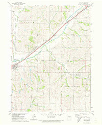
1971 Map of Earling NE
USGS Topo · Published 1973About this map
Agricultural lands in western Iowa are defined here by a network of drainage basins and transport lines in the early 1970s. The landscape is carved by the winding paths of Coon Creek, Walnut Creek, and Buck Creek, which dictate the rural road grid and field patterns of Washington, East Boyer, and Denison townships. The Chicago Milwaukee St Paul and Pacific railroad cuts through the southern portion of the quadrangle, serving as a primary corridor for the region's grain-based economy.
Find a feature on this map
14 named features on this map. Tap any name to fly to it.
Don’t see what you’re looking for? This feature index may not catch every label — zoom into the map to look around manually.
Map Details
Editions of this 1971 Earling NE Map
This is the sole edition of this map. No revisions or reprints were ever made.
Other maps of this area

1954 · Omaha
USGS Topo · 1:250,000

1954 · Fort Dodge
USGS Topo · 1:250,000

1957 · Omaha
USGS Topo · 1:250,000

1957 · Fort Dodge
USGS Topo · 1:250,000

1958 · Omaha
USGS Topo · 1:250,000

1958 · Fort Dodge
USGS Topo · 1:250,000

1971 · Earling
USGS Topo · 1:24,000

1971 · Denison
USGS Topo · 1:24,000
1971 · Dow City
USGS Topo · 1:24,000

1971 · Defiance
USGS Topo · 1:24,000