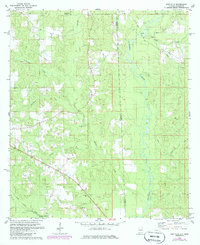
1982 Map of Earlville
USGS Topo · Published 1986About this map
The Escatawpa River defines the landscape of the Alabama-Mississippi border in the early 1980s, winding south through a network of tributary creeks including Brushy Creek, Tennessee Creek, and Puppy Creek. This rural corridor is anchored by the Illinois Central Gulf railroad, which cuts diagonally across the southwestern corner through Shipman. The settlement of Earlville sits in the north, while smaller community centers are represented by local landmarks such as Macedonia Ch, Oak Grove Ch, and Mt Olive Ch. Extensive woodland and resource extraction, evidenced by a Sandpit near Scarborough Creek, contrast with the localized gathering places like Roadside Park. Genealogists may find value in the specific locations of rural burials, including the Moffet Cem and other marked Cem sites found near the rail line and creek beds.
Find a feature on this map
25 named features on this map. Tap any name to fly to it.
Don’t see what you’re looking for? This feature index may not catch every label — zoom into the map to look around manually.
Map Details
Editions of this 1982 Earlville Map
3 editions found
Other maps of this area

1941 · Lucedale
USGS Topo · 1:62,500

1942 · Deer Park
USGS Topo · 1:62,500

1942 · Wilmer
USGS Topo · 1:62,500

1943 · Lucedale
USGS Topo · 1:62,500

1943 · Deer Park
USGS Topo · 1:62,500

1944 · Wilmer
USGS Topo · 1:62,500

1953 · Hattiesburg
USGS Topo · 1:250,000

1953 · Mobile
USGS Topo · 1:250,000

1957 · Mobile
USGS Topo · 1:250,000

1958 · Hattiesburg
USGS Topo · 1:250,000