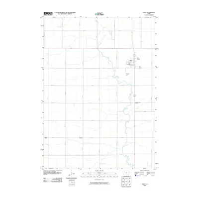
2010 Map of Early
USGS Topo · Published 2010About this map
Early serves as the primary hub of this west-central Iowa landscape, defined by a rigid section-line road grid that segments the fertile terrain. The Boyer River meanders southward through the center of the sheet, providing a natural contrast to the straight paths of Ira Ave and Jackson Ave. This 2010 survey highlights the community's established infrastructure, including the Early Post Office and several significant burial grounds such as Sacred Heart Cemetery and Early Union Cemetery.
Find a feature on this map
22 named features on this map. Tap any name to fly to it.
Don’t see what you’re looking for? This feature index may not catch every label — zoom into the map to look around manually.
Map Details
Editions of this 2010 Early Map
This is the sole edition of this map. No revisions or reprints were ever made.
Other maps of this area

1954 · Fort Dodge
USGS Topo · 1:250,000

1957 · Fort Dodge
USGS Topo · 1:250,000

1958 · Fort Dodge
USGS Topo · 1:250,000

1979 · Lakeside
USGS Topo · 1:24,000

1979 · Newell West
USGS Topo · 1:24,000

1979 · Schaller North
USGS Topo · 1:24,000

1980 · Odebolt East
USGS Topo · 1:24,000

1980 · Early
USGS Topo · 1:24,000

1980 · Lake View
USGS Topo · 1:24,000
1980 · Sac City West
USGS Topo · 1:24,000