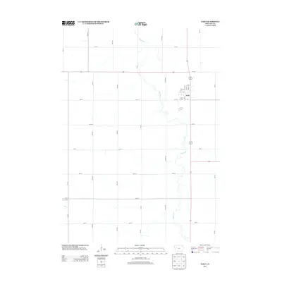
2013 Map of Early
USGS Topo · Published 2013About this map
Early serves as the primary municipal center in this section of Sac County, defined by a rigid grid of residential and commercial streets. The town’s layout, anchored by N Main St and Walnut St, reflects the organized growth of Iowa’s agricultural hubs. Beyond the structured blocks of the settlement, the landscape transitions into the wandering path of the Boyer River, which meanders southeastward across the prairie. The contrast between the rectilinear road network, including long-stretching corridors like Jackson Ave and 230th St, and the irregular hydrology of Elk Cr illustrates the intersection of human engineering and the natural drainage patterns of the region. Local landmarks such as the Prairie Pedlar offer a window into the specialized land use and community points of interest that characterize this corner of the state in the early 21st century.
Find a feature on this map
29 named features on this map. Tap any name to fly to it.
Don’t see what you’re looking for? This feature index may not catch every label — zoom into the map to look around manually.
Map Details
Editions of this 2013 Early Map
This is the sole edition of this map. No revisions or reprints were ever made.
Other maps of this area

1954 · Fort Dodge
USGS Topo · 1:250,000

1957 · Fort Dodge
USGS Topo · 1:250,000

1958 · Fort Dodge
USGS Topo · 1:250,000

1979 · Lakeside
USGS Topo · 1:24,000

1979 · Newell West
USGS Topo · 1:24,000

1979 · Schaller North
USGS Topo · 1:24,000

1980 · Odebolt East
USGS Topo · 1:24,000

1980 · Early
USGS Topo · 1:24,000

1980 · Lake View
USGS Topo · 1:24,000
1980 · Sac City West
USGS Topo · 1:24,000