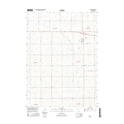
2015 Map of Early
USGS Topo · Published 2015About this map
Early serves as the central hub of this agricultural landscape in Sac County, where the geometric grid of county roads defines the rural character of the region. The settlement is anchored by a cluster of civic and spiritual landmarks, including Sacred Heart Cem and Early Union Cem just to the east. These local burial grounds, alongside the Protestant Union Cem and Immanuel Cem further south, provide significant touchpoints for genealogists tracing family histories in this corner of Iowa.
Find a feature on this map
36 named features on this map. Tap any name to fly to it.
Don’t see what you’re looking for? This feature index may not catch every label — zoom into the map to look around manually.
Map Details
Editions of this 2015 Early Map
This is the sole edition of this map. No revisions or reprints were ever made.
Other maps of this area

1954 · Fort Dodge
USGS Topo · 1:250,000

1957 · Fort Dodge
USGS Topo · 1:250,000

1958 · Fort Dodge
USGS Topo · 1:250,000

1979 · Lakeside
USGS Topo · 1:24,000

1979 · Newell West
USGS Topo · 1:24,000

1979 · Schaller North
USGS Topo · 1:24,000

1980 · Odebolt East
USGS Topo · 1:24,000

1980 · Early
USGS Topo · 1:24,000

1980 · Lake View
USGS Topo · 1:24,000
1980 · Sac City West
USGS Topo · 1:24,000