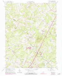
1965 Map of Earlysville
USGS Topo · Published 1990About this map
The North Fork Rivanna River system anchors this survey of northern Albemarle and southern Greene counties, where the Lynch River and Roach River converge near the rural crossroads of Roach and Lynch. This mid-century landscape is defined by its small community centers and country churches, including Chestnut Grove Ch and Mt Zion Ch. To the south, the emergence of the Charlottesville-Albemarle Airport and local landmarks like the Broadus Wood Sch in Earlysville signal the transition from a purely agrarian economy to one supporting modern infrastructure. Notable historic transport features include the Southern RR Grade following Turkey Run and the old milling site at Advance Mills. The terrain is marked by prominent peaks such as Piney Mountain and Frays Mountain, which overlook the numerous family-named branches and runs that feed the Rivanna.
Find a feature on this map
47 named features on this map. Tap any name to fly to it.
Don’t see what you’re looking for? This feature index may not catch every label — zoom into the map to look around manually.
Map Details
Editions of this 1965 Earlysville Map
4 editions found
Other maps of this area

1892 · Gordonsville
USGS Topo · 1:125,000

1892 · Harrisonburg
USGS Topo · 1:125,000

1930 · Madison
USGS Topo · 1:48,000

1931 · University
USGS Topo · 1:62,500

1933 · Madison
USGS Topo · 1:62,500

1935 · Charlottesville
USGS Topo · 1:62,500

1935 · University
USGS Topo · 1:62,500

1937 · Elkton
USGS Topo · 1:62,500

1939 · Charlottesville
USGS Topo · 1:62,500

1949 · Charlottesville
USGS Topo · 1:250,000